The Lemon Bay Basin is located within CHNEP and spans 132.1 square miles. The basin extends from South Venice to the Gasparilla Island Causeway and contains 29 named lakes/ponds, 48 named rivers/streams/canals and 2 named bays/bayous. Due to high amounts of urban land use, the basin has been impacted by stormwater runoff, channelization of natural streams, increase of impervious surfaces, and conversion of natural habitat to other land uses. The tributaries to the estuary have also been transformed by ditching for mosquito control and development activities.
This basin is located within: Lemon Bay Watershed
View Maps / Data
CHNEP's Comprehensive Conservation and Management Plan (CCMP) identified four action plans: water quality improvement; hydrological restoration; fish, wildlife, and habitat improvement; and public engagement. Click on the interactive maps below to view data associated with these goals and actions.
Water Quality Snapshot
The Water Quality Snapshot compares the most current water quality data to applicable water quality standards for Chlorophyll a, Phosphorus, Nitrogen, Bacteria, and Dissolved Oxygen to provide a snapshot of how a waterbody is doing. Water quality standards are outlined in Florida Administrative Code 62-302 for fresh/marine waterbodies of different types and uses. A Water Body Identification number (WBID) is an assessment unit that is intended to represent Florida’s waterbodies at the watershed or sub-watershed scale. The assessment units are drainage basins, lakes, lake drainage areas, springs, rivers and streams, segments of rivers and streams, coastal, bay and estuarine waters in Florida.
Showing water quality snapshots for 1 out of 24 WBIDs. View data for all WBIDs
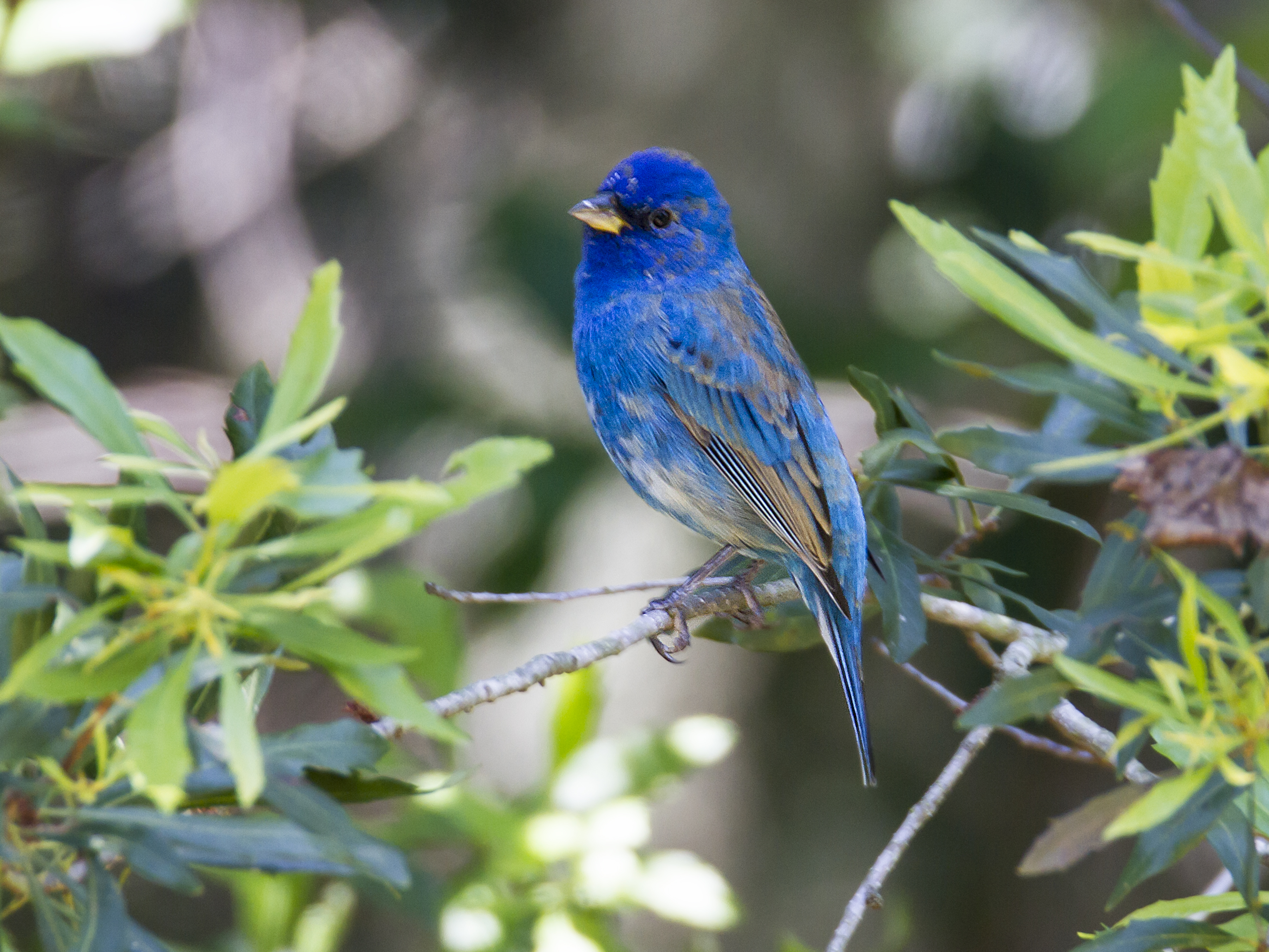
1983A1 - LEMON BAY (NORTH SEGMENT)
(percent (%))
Chart
(µg/L)
Chart
(mg/L)
Chart
(mg/L)
Chart
1983A - UPPER LEMON BAY
1983A2 - RED LAKES ESTUARY
1983B - LOWER LEMON BAY
2030 - ALLIGATOR CREEK (TIDAL SEGMENT)
2030A - ALLIGATOR CREEK
2030B - VENICE GARDENS LAKE
2039 - FORKED CREEK
2042 - WOODMERE CREEK
2049 - GOTTFRIED CREEK
2050 - TRIBUTARY TO GOTTFRIED CREEK
2051 - ENGLEWOOD COASTAL DRAINAGE
2052 - ROCK CREEK
2066A - EAST DRAINAGE WATERWAY
2067 - OYSTER CREEK
2068 - BUCK CREEK
2072 - DIRECT RUNOFF TO BAY
2074B - ALLIGATOR CREEK (TIDAL SEGMENT)
2075B - DON PEDRO ISLAND
2075D - MANASOTA KEY
2076 - LEMON CREEK
2078A - CORAL CREEK (WEST BRANCH)
2078B - CORAL CREEK (EAST BRANCH)
8054 - GULF OF MEXICO (CHARLOTTE COUNTY; SARASOTA COUNTY)
View Detailed Data About the Following Topics:
Geography / Land Use(Population, Land Acquisition and Protection, Land Use / Land Cover)
Population
The following information illustrates the change in population within this water resource during the past few decades. Statistics shown are only for the water resource area within the boundary of this Water Atlas.
Total Population for Lemon Bay Basin
Year | Total Population |
---|---|
1970 | 4,666 |
1980 | 8,061 |
1990 | 31,968 |
2000 | 37,217 |
2010 | 40,154 |
2015 | 39,904 |
2020 | 47,511 |
Land Acquisition and Protection
The Florida Natural Areas Inventory is the primary source for information on Florida's conservation lands. The Inventory database includes boundaries and statistics for more than 1,400 federal, state, local, and private managed areas, all provided directly by the managing agencies. National parks, state forests, wildlife management areas, local and private preserves are examples of the managed areas included.
Statistics shown are only for the watershed area within the boundary of this Water Atlas.
10.6% of the land area within the Lemon Bay Basin is under protection.
Amount of protected land under federal, state, local, and private ownership
Ownership | Area (square miles) |
---|---|
Federal | 0 |
Local | 3.42 |
Private | 0.05 |
State | 10.52 |
Land Use / Land Cover
Land Cover categorizes the land in terms of the observed physical surface characteristics. For example, while the land use may be classified as agricultural, the land cover may be classified as upland or wetland. Learn more about land use and land cover »
Interactive Land Use Viewer
Urban & Built-up
Agriculture
Rangeland
Upland Forests
Water
Wetlands
Barren Land
Utilities
Basin Boundary
Acreage and Percentage within each Land Use / Land Cover Category for Lemon Bay Basin
Year | Urban & Built-up | Agriculture | Rangeland | Upland Forests | Water | Wetlands | Barren Land | Transportation and Utilities | ||||||||
---|---|---|---|---|---|---|---|---|---|---|---|---|---|---|---|---|
Acres | % | Acres | % | Acres | % | Acres | % | Acres | % | Acres | % | Acres | % | Acres | % | |
2020 | 38,263 | 45 | 3,299 | 4 | 4,841 | 6 | 8,953 | 11 | 19,391 | 23 | 8,407 | 10 | 76 | < 1 | 1,462 | 2 |
2017 | 38,139 | 45 | 3,452 | 4 | 4,985 | 6 | 9,109 | 11 | 19,256 | 23 | 8,375 | 10 | 34 | < 1 | 1,344 | 2 |
2014 | 22,609 | 27 | 2,950 | 4 | 3,881 | 5 | 6,422 | 8 | 42,348 | 50 | 5,629 | 7 | 19 | < 1 | 747 | < 1 |
2011 | 22,601 | 27 | 2,948 | 4 | 3,880 | 5 | 6,420 | 8 | 42,333 | 50 | 5,627 | 7 | 19 | < 1 | 747 | < 1 |
2010 | 22,482 | 27 | 4,041 | 5 | 2,856 | 3 | 6,401 | 8 | 42,398 | 50 | 5,606 | 7 | 43 | < 1 | 747 | < 1 |
2009 | 22,409 | 27 | 3,970 | 5 | 2,886 | 3 | 6,790 | 8 | 42,314 | 50 | 5,495 | 7 | 43 | < 1 | 698 | < 1 |
2008 | 22,018 | 26 | 3,933 | 5 | 3,310 | 4 | 6,875 | 8 | 42,288 | 50 | 5,422 | 6 | 52 | < 1 | 677 | < 1 |
2007 | 21,850 | 26 | 3,229 | 4 | 3,852 | 5 | 7,220 | 9 | 42,291 | 50 | 5,412 | 6 | 51 | < 1 | 670 | < 1 |
2006 | 21,489 | 25 | 2,184 | 3 | 4,856 | 6 | 7,553 | 9 | 42,303 | 50 | 5,484 | 7 | 42 | < 1 | 664 | < 1 |
2005 | 21,383 | 25 | 2,122 | 3 | 4,853 | 6 | 7,654 | 9 | 42,318 | 50 | 5,527 | 7 | 37 | < 1 | 681 | < 1 |
2004 | 21,383 | 25 | 2,223 | 3 | 5,136 | 6 | 7,392 | 9 | 41,895 | 50 | 5,276 | 6 | 61 | < 1 | 661 | < 1 |
1999 | 20,897 | 25 | 2,809 | 3 | 4,610 | 6 | 7,950 | 10 | 41,710 | 50 | 5,631 | 7 | 78 | < 1 | 340 | < 1 |
1995 | 20,857 | 25 | 2,719 | 3 | 4,259 | 5 | 8,530 | 10 | 41,808 | 50 | 5,505 | 7 | 22 | < 1 | 326 | < 1 |
1990 | 21,024 | 25 | 2,998 | 4 | 1,838 | 2 | 10,596 | 13 | 41,876 | 50 | 5,907 | 7 | 89 | < 1 | 271 | < 1 |
Recreation
Find maps and waterway navigation guides, descriptions of facilities and recreational amenities, as well as warnings and restrictions pertaining to their use.
Photos
Click on a thumbnail photograph to view the full size version with credits and a description.

Stump Pass panoramic
Credit: Jim Bellino

Beach at Stump Pass
Credit: Mike Herms

Young Alligator
Credit: Eva Furner

Loggerhead Hatchling on Manastoa Key
Credit: Linda Moreau

Male Indigo Bunting
Credit: Eva Furner

Sandhill Crane and Colt
Credit: Mary Lundeberg

Roseate Spoonbill at Myakka State Park
Credit: Mary Lundeberg

Zebra Swallowtail Butterfly
Credit: Eva Furner

Green Turtle Hatchling
Credit: Mary Lundeberg
Great Blue Herons in breeding plumage
Credit: Linda Thompson

Loggerhead Hatchling
Credit: Linda Moreau

Great Egret
Credit: Steve Russell

Bottlenose Dolphin at Stump Pass
Credit: Melissa Herrick

Dead trees at Stump Pass with approaching storm
Credit: Jim Bellino
Cownose Ray
Credit: Linda Moreau

A Branch for a Heart-Courting Egrets
Credit: Norm Collin

American Bald Eagle
Credit: Joel Riloff

Don Pedro Island
Credit: Lisa Rogers
River Otter
Credit: Jonathan Crossman
Alligator
Credit: Ken Hubley
Related Information
education Links
- Adventures in the Charlotte Harbor Watershed: A Story of Four Friends and Their Neighbors 13 of 16
- Florida Marine Science Educators Association
fish and Wildlife Links
View All Related Linksgeneral Links
- 2014 Watershed Summit: Our Vision in Action
- 2017 Southwest Florida Estuaries Report Card
- A primer on sea level and sea-level rise for Longboat Key and the barrier island communities of sout
- Access the FNAI website to view a Florida Conservation Land interactive map
- City of North Port
- Comprehensive Lakes Management Plan -- 2006 Update
- Englewood Community Redevelopment Area Green Infrastructure Best Management Practice Evaluation
- Keep Charlotte Beautiful brochure
- LAKEWATCH Report for Woodmere in Sarasota County Using Data Downloaded 10/17/2016
- Lemon Bay Watershed Management Plan (outline with links to chapters)
geography and Land Use Links
View All Related Linkshabitats and Ecology Links
- Habitat Restoration in Charlotte Harbor
- Habitat Restoration Needs Plan for the Coastal and Heartland National Estuary Partnership Area
- Lemon Bay Hydric Soils 1970s
- Lemon Bay Preserve Ecosystem Restoration Phase I
- Lemon Bay Preserve Habitat Improvement Projects
- Lemon Bay Preserve Prescribed Burn
- Lemon Creek Wildflower Preserve
- Map: Lemon Bay Preserve Burn Zones and Hydrologic Restoration
- NPDES Year 2000 Biological Community Analysis for Big Slough, Hudson Bayou, and Phillippi Creek
- The Peace River and the Cooperative Conservation Blueprint
overview / Current Conditions Links
View All Related Linksprograms & Projects Links
- 2008 HBMP Annual Data Report - Part 1
- 2008 HBMP Annual Data Report - Part 2
- 2008 HBMP Annual Data Report - Part 3
- 2022 Alligator Creek Stream Restoration Project
- Charlotte Harbor Aquatic Preserve Map
- Charlotte Harbor Aquatic Preserves Management Plan (2016)
- FYI / Lemon Bay Park Volunteers
- HBMP 2002 Comprehensive Summary Report--Sept 2004 (Part 1)
- HBMP 2002 Comprehensive Summary Report--Sept 2004 (Part 2)
- HBMP 2006 Comprehensive Summary Report--Dec 2009 (Part 1)
recreation Links
- Amberjack Environmental Park
- Ann and Chuck Dever Regional Park
- Bill Coy/Buck Creek Preserve
- Cedar Point Environmental Park
- Gulf Coast Heritage Trail
- Historical Geography of Southwest Florida Waterways: Anna Maria Sound to Lemon Bay (PDF)
- Stump Pass Beach State Park
- Suncoast Reef Rovers
stormwater Links
- Our Watershed, Our Responsibility: New College, Sarasota, FL (Video)
- Stormwater Capital Improvement Program Lemon Bay Watershed
- Stormwater: A Mixed Blessing
water Levels and Flows Links
- 2015 LIDAR Map of Charlotte County
- Assessment of the Hydraulic Connection Between Ground Water and the Peace River
- Coastal Fringe Phase 2 Lemon Bay Watershed Management Plan Final Report
- Cumulative Risk of Decreasing Streamflows in the Peace River Basin
- Flood Plain Management Study Cow Pen Slough Watershed
- Hydrologic Conditions that Influence Streamflow Losses in a Karst Region of the Upper Peace River...
- Lemon Bay Preserve Weir Project Location
- Lemon Bay Weir Modification Plan
- Saltwater Intrusion and the Minimum Aquifer Level in the Southern Water Use Caution Area
- Sea Level Rise Working Group Report: Vulnerability Assessment and Initial Recommendations
water Quality Links
- Alligator Creek WBID 2030 TMDL Implementation Plan
- Approval Letter for Alligator Creek Implementation Plan
- Assessment of Present and Future Nitrogen Loads, Water Quality, and Seagrass... in Lemon Bay
- Charlotte Harbor Numeric Nutrient Criteria: Task 9, Downstream Protection Values
- Coastal Fringe Phase 3 Watershed Management Plan Final Report
- EPA TMDL: Fecal Coliform TMDL for Peace Creek Drainage Canal
- Evaluation of FDEP Verified Impaired List for Lakes and Streams within Polk County (2013)
- Lemon Bay 208 Program Water Quality Study Appendices
- Lemon Bay 208 Program Water Quality Study, Part I
- Lemon Bay 208 Water Quality Study, Executive Summary
2 Year Graph
10 Year Graph
Seasonal Variation Graph
Graph Details and Help
Water quality data is displayed as a scatter-plot with data from individual sampling events displayed by date, for the previous two- and ten-year periods. Data from all available sources are plotted together. Clicking on a graph will open a larger version of it. To view/download data older than ten years, or to view/download data from individual data source(s), click the "Download Data" icon or button.
The scale used is chosen to accommodate typical values for the water quality parameter being graphed. Units are shown on the y-axis and in the graph title.
Graphs are generated and stored in the Water Atlas database on a periodic basis using an automated process. The date when the graph was created is shown.
The Seasonal Variation Graph displays a statistical summary of data from all available data sources for the entire period of record. It is used to illustrate typical variation in the selected water quality parameter from month to month during the year. The diagram below shows how to read the graph:

The median value is shown. Although not specifically marked on the graph, the mean (average) value is midway between the 25th and 75th percentiles.
The "whiskers" indicate the range of the sample values; those that are outside pre-defined "Minimum" and "Maximum" values are excluded. Sample data less than the Minimum or greater than the Maximum are considered to be outliers and are not displayed on the graph.